delta city
Year: 2011
Size: 500 ha
Type: research
Location: Queens, New York, USA
Partner in charge: Chen Chen

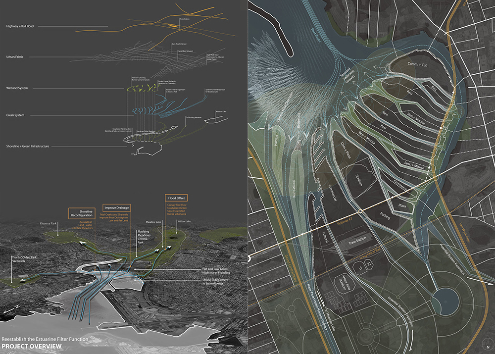
Willets Point in Flushing, Queens, New York is a heavily urbanized estuary whose ecological conditions have been subject to a serious degradation over the past century. It is also a relatively low and flat site, thus vulnerable to 100-years flooding. This project takes the current pressure for urban redevelopment as an opportunity to propose an innovative infrastructural framework for the site, exploring new urban typologies that are driven by ecological and environmental dynamics.
The current coastline, generated by a bulkhead of highly engineered seawalls marks a clear differentiation between water and land that rejects any form of tidal dynamics. In our project this existing infrastructure is substituted by a more resilient land-water interface that can gradually recover a healthy estuary ecology. A series of tidal channels mitigates the flooding risk by releasing flood water to adjacent water bodies and green spaces during extreme storm events. The new channels structure and divide the site into a series of islands. Various buffer zones along the streams generate different types of urban open spaces and work as flood plains during the fluvial processes. Meanwhile, a system of storm water wetlands located upland delays the surface water runoff and treats the storm water before conveying it to the estuary bay.
The concept of “living with flooding” is explored as an alternative model of inhabiting this problematic, fragile and complex ecological context. A strategy of vertical zoning is developed through a series of elevational relationships, intentionally allowing some areas (mostly parking, and open spaces) to be occasionally flooded during storm events, in order to prioritize the protection of the zones with denser urban development or strategic programmatic importance.
The water system is also the key driver for the creation of a new network of open spaces, pedestrian paths and built volumes, triggering the emergence of new housing typologies, with innovative streetscapes and building–landscape relationships. Various modules and distributions of storm water wetlands create urban blocks of different sizes and a branching water network provides continuous pedestrian paths through all the open spaces. Punctual earthwork provides the site with a new micro-topography that collects and distribute storm water, while creating unique spatial conditions. These new features not only reactivate the estuary ecologies but also contribute to strengthen the local identity of the site, increasing its land value. In this way, the project generates a synergy between economy and ecology, so often conflicting with each other in the global context of environmental degradation and speculative urbanization.
位于纽约皇后区法拉盛的Willets Point是一个高密度的城市街区,这一河口地带的生态环境从上世纪以来不断地受到工业污染等严重损害。同时,这里地势低洼平坦,一直面临洪水的威胁。该项目以旧城改造为契机,试图为该地段提出一种创新的基础设施系统,试图从生态和环境保护的观念出发提出新的建筑和景观设计。
现有海岸线是一个坚实的混凝土人工海堤,将海与城市明显分界,完全将潮汐挡在其外。我们提出了一个更亲水、更生态的海岸线方案,以便恢复三角洲区域的健康生态系统。一系列的潮汐通道构成一个抗洪系统,在洪水爆发时能有效地将洪水疏散至周边的水体和绿地,以保护高密度的城区。这个水系统同时形成一系列的岛屿,沿河的不同缓冲区域产生不同的公共绿地,并在降雨的过程中作为泄洪区。这与湿地系统一同减缓地表径流的疏散过程,还具有治理水污染及改善生态环境的功能。
“与洪水同住”设计概念是对这个问题众多、复杂而脆弱的地段的积极回应。我们通过一系列的标高关系开展了纵向分区的策略,有意识的允许一些区域(主要是停车场,公共绿地等)暂时被洪水淹没,以此实现对于高密度城市化地区或战略性功能地区的重点保护。
水系统也对公共空间网络、步行网络和建筑形态的重塑起到主导的影响,通过对建筑类型和街道的设计,建筑与景观之间在平面和剖面上都产生了有趣丰富的关系。此外,多样的湿地模数与分布帮助组织不同建筑组群,水系统的支流能提供贯穿所有公共空间的连续步道系统。对地形的调整本着最小化土方移动的原则,巧妙的利用局部微地形组织地表径流,形成独特有趣的空间体验。方案中的各系统不仅帮助激活三角洲地区的生态,还突出了场地的地方特质,提高了土地价值。它试图调解城市发展和生态保护这看似互相对立的两方面 ,将经济因素和生态因素一同纳入到城市规划的考虑中来,探索了一种整合、共生以及双赢的城市发展模式。