jianshi
Year: 2012
Size: 2,000 ha
Type: research
Location: Jianshi, Hubei, China
Partners in charge: Federico Ruberto, Nicola Saladino
External collaborator: Design and Research Institute of Hunan University

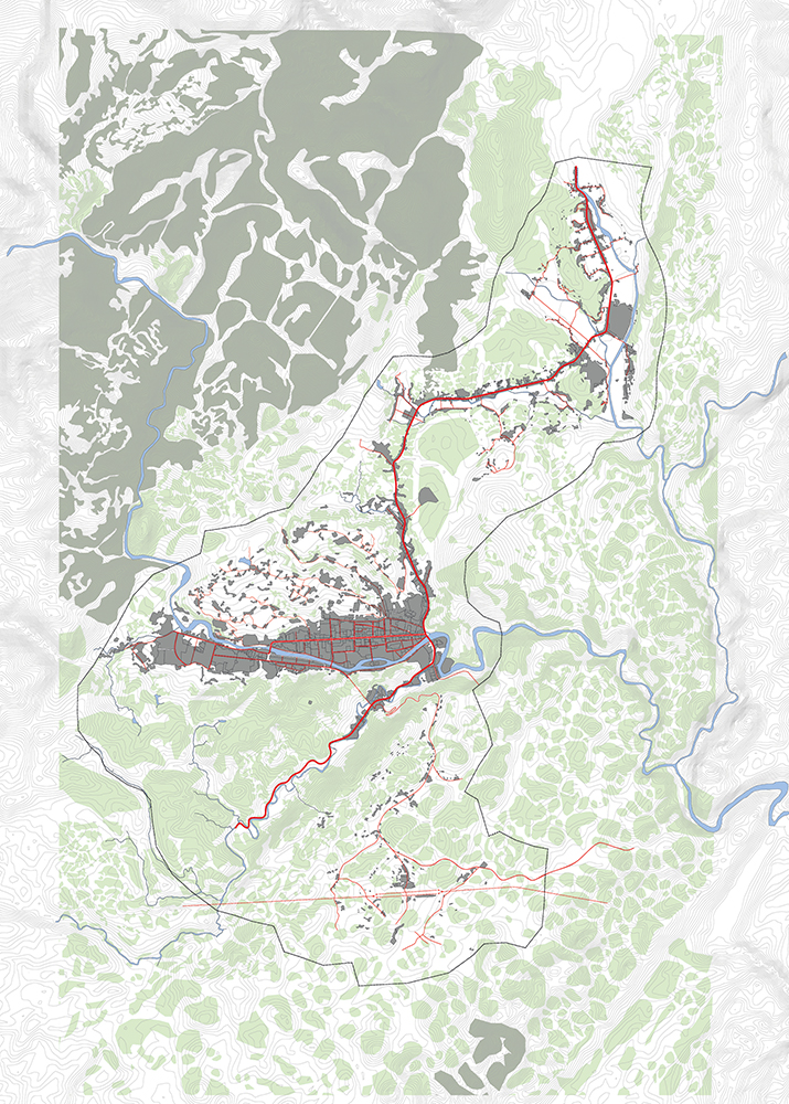
This project is the result of a collaboration with the Design and Research Institute of Hunan University. The Institute had been working for several months on the masterplan of Jianshi, a small city located in a mountainous area of the Hubei province. Our task was to analyse and assess the potentials and weaknesses of the existing proposal and provide possible alternatives. The city is planned to expand from 50.000 to 200.000 inhabitants in the next 10 years, practically occupying the totality of the available flat land that is currently used for agricultural production. As a result of such expansion the economy of the city is also meant to evolve from primary to secondary and tertiary industry, generating an important and potentially violent rupture with its traditional identity.
Although the infrastructure and the urban fabric are carefully designed, taking into consideration the particular morphology of the terrain, and the functional distribution avoids most of the typical problems related to mono-functional zoning, the original masterplan seems to lack a clear phasing strategy and does not take full advantage of the potentials of the natural context. Thus we elaborate a scheme that is in-formed by the materiality of the site, constituting an energetic material assemblage that can build-up a dialogue between the topography, the soil and the hydrology of the site on the one hand and the functionality and quality of the urban space on the other. We propose a system of synergies in which the urban fabric is spatially and symbiotically articulated over the natural environment, actively enhancing its potentials. Within an integrated system of green corridors, the productive landscape then becomes an important element of the public space. Analysing the quality and productivity of the landscape, we are able to create a sequence of spatial transformations that preserves the most valuable natural elements and allows a smoother transition from the rural to the new urban economy.
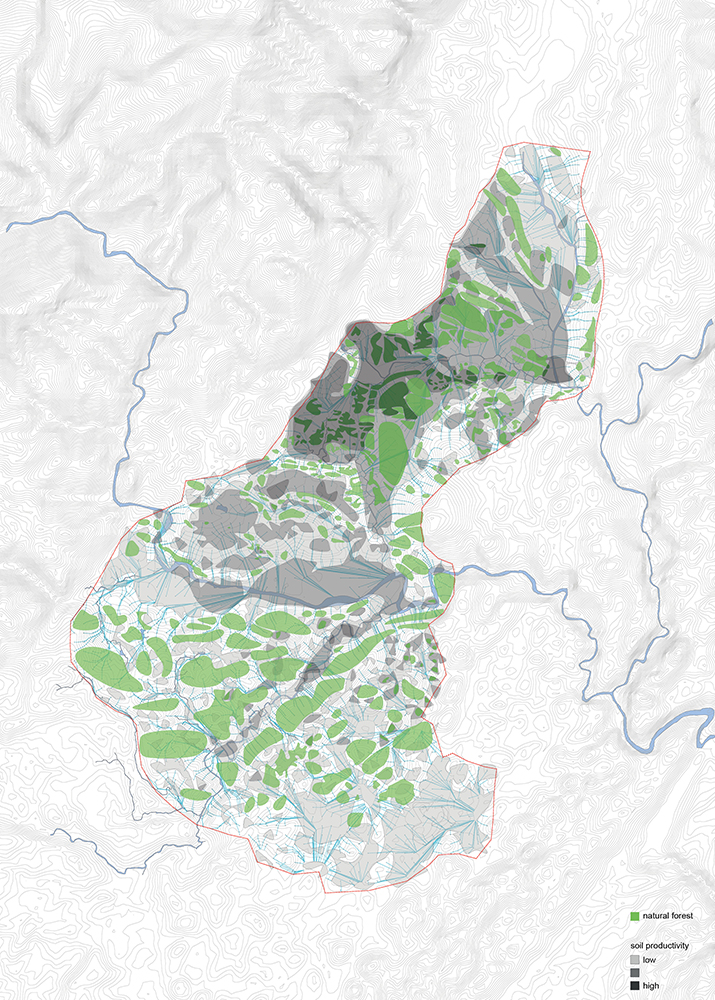
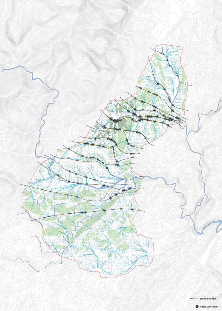
In terms of design process, we divided our research in two branches, natural and artificial, which are then re-described as a single system of qualities, quantities and performances - i.e. intensities. Through the indexing of the site (for a deeper understanding of the term and methodology, please refer to the academic section of the site) we generate maps and diagrams that are the graphic translation of specific systems of relations. The quantity and qualities extracted from the analysis of different layers are then dissected and recombined to produce a more comprehensive and holistic knowledge of the territory. The soil productivity is evaluated through the combination of: slope analysis, accessibility and developable areas; water run-off, possible water collection systems and potential hazards; soil quality and solar radiation levels. The configuration of the green corridors is then mediated by the existing vegetation, the main infrastructure and a logic of spatial sequences related to the public space. Finally the road network is punctually redesigned in order to generate loops that allow an easier implementation of the public transportation system.
这个项目是reMIX临界工作室与湖南大学设计研究院合作设计。建始县是湖北省山区的一座小型城市,当时设计院已经在该城市总体规划上投入了几个月的时间。我们在该项目中负责分析和评估现有方案的潜力以及薄弱环节,并提出改进的可能性。在接下来的十年里,建始县人口将由如今的5万增长至20万,若维持现有的城市密度, 城市化将会吞噬掉现有平坦区域上的耕地。随着人口增长,城市经济发展目标也将由第一产业向第二、第三产业转移,建始县也将不可避免的面临与传统特征割裂的局面。
现有规划方案结合当地特殊地势条件,合理解决了城市肌理的梳理及市政设施的敷设,也避免了如单一功能区划的问题。但是,这个方案缺乏城市分期发展的策略,并未能充分利用当地自然环境所带来的优势和潜力。据此,我们提议建立一个综合体系作为优化方案,能够因地制宜,使城市的空间形态,功能结构与当地的地形,土壤和水文系统更好的协调。使场域性、类型化的城市肌理能够更顺畅的融入周边环境,并更合理的利用自然资源。城市景观廊道系统中的农业景观将成为与城市空间密切结合的公共空间。通过对地形、光照、坡度等不同因素的分析,我们评价了不同区域土壤的生产力,一方面确定了生态价值较高的自然保护区域,一方面实现农业向新城市产业的平稳过渡。
在设计过程中,我们将研究划分为两大分支:自然系统和人工系统,并最终将这两个系统用统一的参数来归纳和描述:质量,数量,功能,强度。通过对地段的参数化分析(若要深入了解,请参见学术部分首页),我们以测绘和分析图将系统内在关系进行视觉化的表达。最终,我们通过对这些多层次、多数据的分析处理达成对场地的宏观掌控及综合评价。土壤生产力根据以下诸个因素评估:坡度分析,可达性,可建设区域,地表径流,具有雨水收集潜能的地区,受灾系数,土壤性质,阳光照度。我们提出的绿色廊道还充分考虑了已有的植被分布,主要基础设施和公共空间的空间秩序逻辑。最后,为了形成一个更加有效的公共交通体系,我们也对现有路网结构进行了局部调整。